
In one of the most remote and scientifically significant discoveries in recent memory, archaeologists have uncovered 29 human footprints preserved in the shoreline mud of Calvert Island, an isolated landmass off the central coast of British Columbia, Canada. Dating back approximately 13,000 years—during the late Pleistocene epoch—the tracks provide direct, tangible evidence of early human activity along North America’s Pacific coastline. Preserved by sediment and coastal erosion, these ancient imprints offer a rare glimpse into the movements and behaviors of some of the first people to navigate the region, long before the rise of permanent settlements or written records.
The discovery, published in the peer-reviewed journal PLOS One, was led by Duncan McLaren, an archaeologist at the Hakai Institute and Simon Fraser University. The findings are more than a historical curiosity—they represent a crucial piece in the puzzle of how humans first arrived in the Americas. Unlike the more commonly cited Bering Land Bridge theory, which suggests migration across an exposed land connection between Siberia and Alaska, this find supports an alternative but increasingly supported hypothesis: that early humans traveled southward along the Pacific coastline using watercraft.
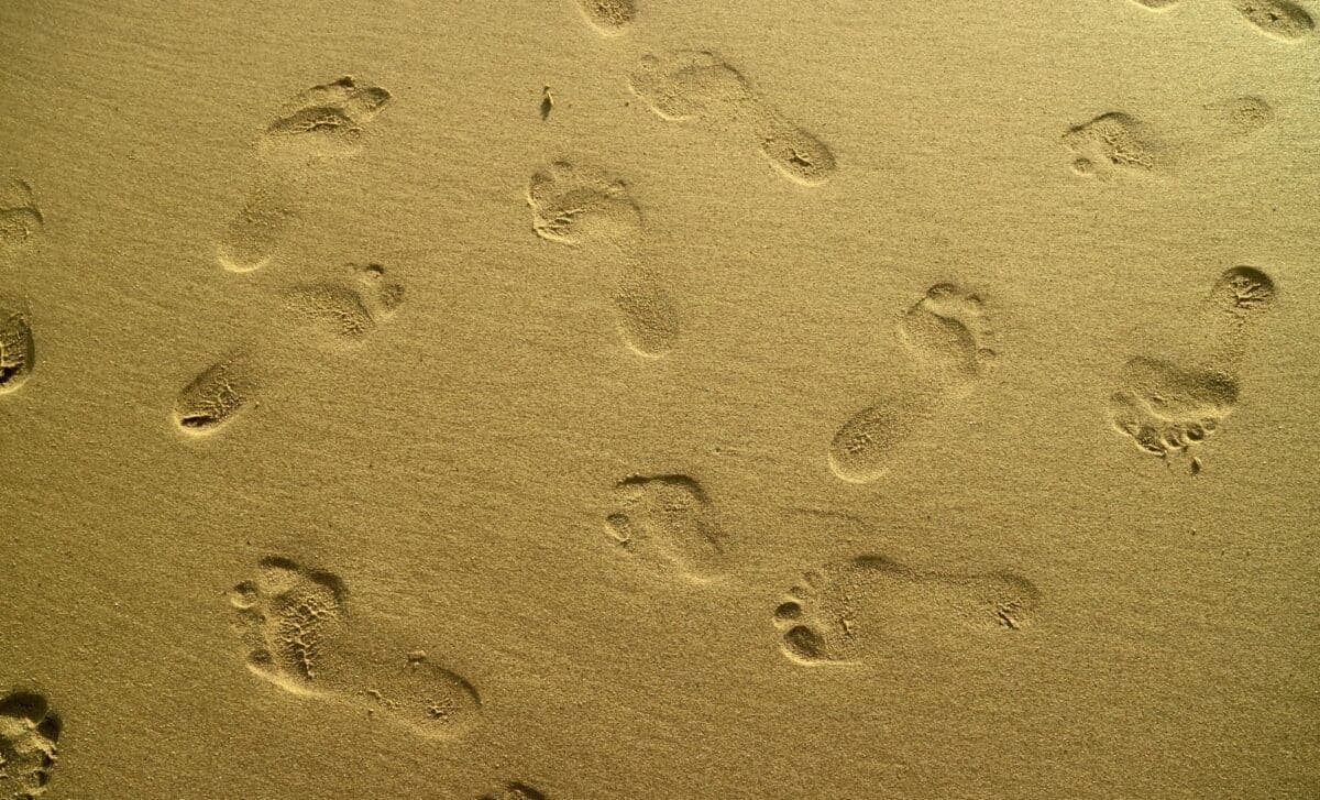
- 29 human footprints, dated to 13,000 years ago, discovered on Calvert Island, British Columbia.
- Footprints belong to three individuals, with sizes suggesting a nuclear family or small group.
- Tracks show signs of barefoot walking along a shoreline, with some heel marks indicating slipping on wet mud.
- Discovery supports the coastal migration route theory for early human movement into the Americas.
- Findings published in PLOS One, led by Duncan McLaren of the Hakai Institute and Simon Fraser University.
How the Calvert Island Footprints Rewrite the Story of Early American Migration
The discovery of these footprints on Calvert Island is not just a local sensation—it challenges long-held assumptions about how humans first entered the Americas. For decades, the dominant narrative has centered on the idea that the first Americans crossed from Asia via the Bering Land Bridge during the last Ice Age, when lower sea levels exposed a vast expanse of land known as Beringia. From there, they are believed to have migrated inland through an ice-free corridor into what is now the continental United States.
However, evidence is mounting that coastal migration may have played a far more significant role. The Calvert Island footprints, along with other recent discoveries—such as stone tools found on California’s Channel Islands—suggest that early humans were adept at navigating coastal waters, using boats or rafts to move along the shoreline. This route would have allowed them to bypass the harsh inland ice sheets and access resources directly from the ocean.
The Role of Sea Level Change in Preserving the Past
The timing of the footprints is crucial. Around 13,000 years ago, global sea levels were significantly lower than today—estimates suggest 6 to 9 feet lower—exposing broad stretches of coastline that are now submerged. These exposed shorelines provided ideal conditions for human activity: access to marine resources like shellfish, fish, and sea mammals; shelter from inland glaciers; and relatively stable, habitable terrain.
As sea levels rose following the end of the last Ice Age, many of these coastal areas were inundated, burying evidence of early human occupation under layers of sediment. The Calvert Island site is rare because the tracks were preserved in fine-grained mud that dried and hardened, protecting them from erosion and disturbance. This preservation allows scientists to study not just the presence of humans, but their behavior—how they moved, where they paused, and even how they interacted with the environment.
What the Footprints Reveal About the People Who Made Them
The footprints themselves are remarkably detailed. Researchers identified 29 distinct impressions, including clear outlines of toes, arches, and heels. Based on size and shape, the team concluded that the tracks were made by three individuals: an adult woman (approximately U.S. women’s size 8–9), a juvenile (around size 8), and a smaller adult, possibly a woman or teenager (size 6–7). The variation in size suggests a family unit—perhaps a mother, child, and another relative—moving together along the shoreline.
“Primarily the three different sizes of footprints found conjures up the image of a nuclear family or small group of people using the area.” — Duncan McLaren, lead author of the study, Hakai Institute and Simon Fraser University
The tracks also tell a story of movement and environment. Some heel marks appear dragged, indicating slipping on soft, wet mud—a detail that confirms the individuals were walking barefoot. The spacing of the prints suggests they were not in a hurry; rather, the group may have been exploring, foraging, or preparing to disembark from a watercraft. Several prints are clustered and face inland, as if the group paused, gathered, or waited before continuing on land.
The Spatial Clues: Why the Arrangement of Footprints Matters
The arrangement of the footprints is as significant as their existence. Unlike a linear trail that would indicate travel in a single direction, the Calvert Island tracks form a loose cluster, with several prints oriented toward the interior of the island. This pattern strongly suggests that the group was not simply passing through but was engaged in an activity—perhaps disembarking from a boat, preparing to set up camp, or socializing.
According to McLaren, the spatial layout indicates a deliberate pause. He noted that the orientation of the prints facing inland aligns with what archaeologists would expect at a coastal landing site. Such locations were critical for early migrants, offering immediate access to food, water, and shelter. The find supports the idea that these shorelines were not just routes of passage but active zones of human settlement and resource exploitation.
“Most of the footprints face inland … and they may represent a place where people were disembarking from watercraft before moving to a drier area.” — Duncan McLaren
Revisiting the Coastal Migration Theory: Why This Discovery Matters
The Calvert Island footprints add critical weight to the coastal migration hypothesis, a theory that has gained traction in recent years. While the Bering Land Bridge remains a plausible entry point for some early groups, the coastal route offers a more flexible and sustainable pathway. It would have allowed humans to follow marine resources, avoid inland obstacles, and adapt to changing environmental conditions.
Neil Thomas Roach, a paleoanthropologist at Harvard University who was not involved in the study, emphasized the broader significance of such finds. He pointed out that while human presence in coastal British Columbia around 13,000 years ago aligns with other archaeological data, the detailed nature of the footprints provides unprecedented insight into daily life.
“I think this study raises more questions than it answers, which is a good thing. Only with further study and excavation of these shoreline surfaces will we fully understand how many track makers were present, what they were doing on these landscapes, and how important shoreline environments were to their survival.” — Neil Thomas Roach, Harvard University
Roach’s comments underscore a key challenge in archaeology: while individual discoveries are groundbreaking, they often raise new questions. How many people were moving along this coast? Did they return seasonally? What tools or technologies did they use? The Calvert Island footprints are a starting point, not a conclusion.
The Broader Context: Other Evidence Supporting Coastal Migration
The Calvert Island discovery is not an isolated case. In 2017, archaeologists uncovered 130,000-year-old stone tools on California’s Channel Islands, far older than previously believed possible for human occupation in North America. These tools, found submerged in sediment, suggested human activity long before the conventional Clovis culture timeline, which dates human presence in the Americas to around 13,000 years ago.
Similarly, in 2019, researchers reported finding human footprints in White Sands National Park, New Mexico, dating back 23,000 years. These discoveries collectively paint a picture of humans adapting to diverse environments—from coastal shorelines to inland lakes—during the late Pleistocene.
Such findings challenge the traditional Clovis-first model, which posited that humans migrated into the Americas around 13,000 years ago and spread rapidly across the continent. Instead, evidence now suggests a more complex, multi-path migration that unfolded over thousands of years, with coastal routes playing a vital role.
The Science Behind Preservation: How Footprints Survive for Millennia
The preservation of footprints for over 13 millennia is a testament to the unique environmental conditions of Calvert Island. Unlike fossilized bones or stone tools, footprints are fleeting traces—easily eroded by wind, rain, or human activity. Their survival here is due to a combination of factors: fine-grained sediment that compacted quickly, rapid burial by rising tides or sediment, and the absence of significant human disturbance in this remote location.
According to McLaren, the site was discovered during a routine coastal survey by the Hakai Institute, a research organization focused on coastal ecosystems and human-environment interactions. The team used a combination of field excavation, 3D scanning, and sediment analysis to document and analyze the footprints without damaging them.
What Comes Next? The Future of Coastal Archaeology in Canada
The Calvert Island footprints are just the beginning. Archaeologists believe that similar sites may exist along the Pacific Northwest coast, hidden beneath rising sea levels or buried under dense vegetation. The Hakai Institute and other research groups are now expanding their surveys to other uninhabited islands in British Columbia, using advanced technologies like LiDAR and drone mapping to identify potential sites.
However, the work is urgent. Rising sea levels, coastal development, and increased erosion threaten to erase these fragile records of the past. McLaren emphasized the need for rapid documentation and protection of such sites, noting that ‘once they’re gone, they’re gone forever.’
Implications for Indigenous History and Cultural Narratives
Beyond the scientific implications, discoveries like the Calvert Island footprints carry deep cultural significance for Indigenous peoples of the Pacific Northwest. Many coastal First Nations, including the Heiltsuk, Wuikinuxv, and Kwakwaka’wakw, have oral histories that speak of ancient migrations along the coast. These scientific findings provide a tangible link between ancestral stories and archaeological evidence.
Archaeologists are increasingly collaborating with Indigenous communities to interpret such discoveries within their cultural contexts. This approach ensures that scientific research respects traditional knowledge and contributes to broader efforts at cultural reclamation and reconciliation.
Frequently Asked Questions
- How do archaeologists date ancient footprints?
- Archaeologists use radiocarbon dating on organic material found in or near the footprints, such as plant remains or sediment layers. In the case of the Calvert Island tracks, charcoal and shell fragments embedded in the sediment provided the necessary material for dating.
- Why are coastal migration routes important in human history?
- Coastal routes allowed early humans to access marine resources, avoid inland ice sheets, and move more efficiently along productive shorelines. This pathway may have been especially critical during the last Ice Age when inland travel was difficult.
- Are there other ancient human footprint sites in North America?
- Yes. The most famous is at White Sands National Park in New Mexico, where 23,000-year-old footprints were discovered. Other potential sites are being studied in California and Alaska, with ongoing research expanding the known record of early coastal migration.