
NASA’s Surface Water and Ocean Topography (SWOT) satellite has delivered a groundbreaking global atlas of tidal rivers, mapping the inland extent of tides in thousands of coastal rivers for the first time. Using two-dimensional swath observations from SWOT’s advanced radar altimeter, scientists have documented tidal dynamics across 165,000 kilometers of river systems—from the Hudson River in New York to the Amazon in Brazil—revealing how tides shape navigation, flood risks, and ecological processes worldwide. This landmark achievement, published in Nature, demonstrates that SWOT’s high-resolution data can accurately measure tidal amplitudes even in complex river systems, offering unprecedented insights into the land–ocean interface.
Why Tides Matter: The Invisible Pulse Shaping Coastal Life and Land
Tides are far more than rhythmic ocean movements—they are the invisible pulse that governs life along coastlines. The term ‘estuary’ itself derives from the Latin *aestuarium*, meaning “the place of the tide,” underscoring the deep connection between tidal forces and coastal ecosystems. Tidal dynamics influence everything from navigation routes for commercial shipping to the frequency of coastal flooding, which has become increasingly critical as climate change intensifies storm surges and sea-level rise.
A Domino Effect on Ecological and Human Systems
Beyond their role in flooding, tides modulate biogeochemical cycles, accelerating nitrification and denitrification in soils and altering nutrient levels in coastal waters. These processes directly impact water quality and the health of salt marshes, which act as natural buffers against storm surges. In agricultural deltas, tidal mixing influences irrigation water salinity, while in urban coastal zones, tidal energy shapes water security for millions. The devastating compound flooding during Hurricane Sandy in 2012—where storm surge coincided with high tide in New York Harbor—served as a stark reminder of how tides and extreme weather can combine to create catastrophic outcomes.
The Challenge of Measuring Tides in Rivers: Why Traditional Methods Fall Short
Despite their importance, measuring tides in rivers has long been a scientific challenge. Traditional satellite altimetry, which uses narrow radar beams to measure water surface elevations, struggles in coastal and inland water bodies due to land contamination of radar returns and insufficient satellite overpass density. These limitations leave critical gaps in data, particularly in estuaries and river mouths where tidal behavior is most complex.
The Limits of Nadir Altimetry
Nadir altimeters, which track water levels directly beneath a satellite, have achieved remarkable accuracy in open ocean settings, with errors as low as 1 centimeter. However, coastal regions present unique obstacles: shallow water dynamics introduce nonlinear effects, and the proximity of land distorts radar signals. Additionally, the density of satellite passes is often too sparse to capture the rapid changes in tidal elevation within rivers. These constraints have historically limited scientists’ ability to model tidal propagation in inland waterways, leaving many questions about global tidal extents unanswered.
How SWOT Revolutionizes Tidal Science with 2D Swath Observations
Launched in December 2022, the SWOT satellite represents a quantum leap in observational capability. Unlike traditional nadir altimeters, SWOT employs a wide-swath interferometric radar system that captures two-dimensional snapshots of both ocean and inland water surfaces. This innovation allows scientists to observe tidal dynamics across entire river systems in a single pass, rather than relying on sparse point measurements.
From Calibration to Science: SWOT’s Dual-Phase Mission
SWOT’s mission has operated in two distinct phases: a calibration and validation (Cal/Val) phase, followed by a science phase. During Cal/Val, the satellite orbited in a tight 1-day repeat cycle, enabling highly accurate tidal retrievals with relatively few observations. Once transitioned to the science orbit, SWOT adopted a 21-day repeat cycle, providing broader coverage but with slightly reduced temporal resolution. Remarkably, analysis shows that tidal amplitude estimates derived from science orbit data alone are nearly as accurate as those combining both phases—validating SWOT’s potential as a global monitoring tool.
- SWOT’s wide-swath radar altimeter captures tidal dynamics in rivers with unprecedented spatial and temporal detail, addressing long-standing gaps in coastal observations.
- Tidal extents in rivers can stretch hundreds of kilometers inland, with significant implications for flood risk, ecosystem health, and water resource management.
- SWOT’s data reveals complex tidal behaviors, including upstream amplification and abrupt changes near dams, challenging traditional assumptions about tidal propagation.
Mapping the Tidal Pulse: SWOT’s Global Atlas of River Tides
Using SWOT’s River Single-Pass Vector Data Product (RiverSP), researchers conducted a harmonic analysis of tidal constituents—specifically the lunar diurnal O1 tide and the lunar semi-diurnal M2 tide—across thousands of rivers from March 2023 to May 2025. The results were validated against 622 in situ tide and river gauge stations worldwide, demonstrating median amplitude errors of just 5.53 cm for M2 and 3.23 cm for O1. These errors are remarkably low, especially considering the complexity of riverine environments.
Validation Against Ground Truth: How SWOT Compares to Traditional Gauges
The study compared SWOT-derived tidal amplitudes with measurements from tide gauges and river gauges globally. For the M2 constituent, median amplitude differences were 5.53 cm, while O1 differences were 3.23 cm. Errors increased with distance from river mouths, reflecting the diminishing tidal signal and greater noise in upstream reaches. Notably, errors were higher at higher latitudes, where sea ice may interfere with radar measurements.
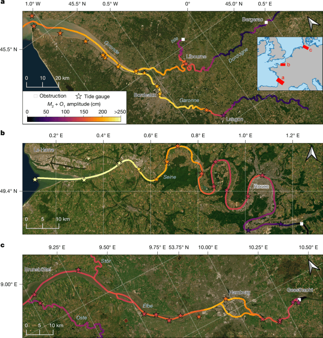
The Gironde, Seine, and Elbe Rivers: A Window into Tidal Complexity
Three rivers—the Gironde Estuary in France, the Seine in France and Germany, and the Elbe in Germany—served as case studies to illustrate SWOT’s capabilities. In the Elbe River, tidal amplitudes exceeded 50 centimeters more than 100 kilometers upstream of the river mouth. Intriguingly, the amplitude increased near Hamburg due to the convergence of river branches, a phenomenon known as upstream amplification. The Seine River showed a more nuanced pattern: tidal amplitude decreased from the mouth, rose again in meanders upstream, and then dropped sharply near a dam—patterns confirmed by in situ observations.
Human Footprint: Dams, Flood Barriers, and the Suppression of Tides
Human infrastructure plays a critical role in shaping tidal extents. Around the world, 16% of observed estuaries contain artificial or natural structures—such as dams, flood barriers, or dykes—that limit tidal influence. In the Seine and Elbe Rivers, tidal amplitudes upstream of dams fell below detectable levels (10 cm), demonstrating how engineering can sever the natural tidal pulse. In contrast, the Gironde Estuary’s Garonne River remains unobstructed, allowing tides to propagate naturally up to 230 kilometers inland before friction dissipates the signal.
The Dutch Paradox: Aggressive Flood Protection Reduces Tidal Influence
In the Netherlands, extensive flood protection systems—including the iconic Maeslantkering storm surge barrier and a network of dikes—have significantly reduced tidal penetration into inland rivers. While this infrastructure protects coastal communities from sea-level rise and storm surges, it also diminishes the ecological benefits of tidal flooding, such as sediment deposition and nutrient cycling. The SWOT data reveals this trade-off, highlighting how human interventions can reshape natural tidal systems on a continental scale.
Statistical Insights: What Controls the Extent of Tides in Rivers?
Using the SWOT River Database (SWORD) and the MERIT-Basins dataset, researchers analyzed tidal extents across 3,172 tidal and likely tidal river systems. The findings reveal that tidal extent scales with several key characteristics: river size (measured by Strahler stream order), tidal amplitude at the river mouth, river mouth width, and average slope of the river channel.
Larger Rivers, Longer Tidal Reaches
The largest rivers, such as the Mississippi, Amazon, and Nile (Strahler order 7 or higher), have a median tidal extent of 161 kilometers, compared to just 13 kilometers in the smallest streams (Strahler order 3 or lower). This pattern underscores how river morphology shapes tidal propagation. Low-gradient rivers with wide mouths—like those in the Amazon basin—allow tidal energy to travel farther inland, while steep, narrow channels dissipate energy quickly.
The Role of Tidal Amplitude and Channel Geometry
Tidal amplitude at the river mouth is a strong predictor of inland tidal extent. Rivers with large ocean tides at their mouths, such as those in the Bay of Fundy (which boasts the highest tidal ranges on Earth), can propagate tidal influence hundreds of kilometers upstream. Channel slope also plays a crucial role: rivers with slopes over 400 millimeters per kilometer have a median tidal extent of only 10 kilometers, while those with slopes under 25 millimeters per kilometer extend 44 kilometers inland on average.
Saltwater Intrusion, Floods, and Food Security: The Real-World Implications of Tidal Data
Tidal data from SWOT has far-reaching implications for managing some of the world’s most pressing challenges. Saltwater intrusion, exacerbated by drought and over-extraction of freshwater, threatens drinking water supplies for millions of people in coastal cities. In agricultural deltas like the Mekong and Nile, salinization of irrigation water can devastate crops, undermining food security. SWOT’s tidal measurements provide critical inputs for hydrodynamic models that predict and manage saltwater intrusion in rivers with sparse ground-based observations.
Correcting Flood Records: How Tidal Data Improves Disaster Assessment
In the Congo River, researchers used SWOT-derived tidal corrections to refine historical flood records. By subtracting tidal influences from satellite water-level measurements, they identified extreme low-flow events that were previously masked by high or low tides. In one case, the corrected data revealed a flood peak two weeks earlier than uncorrected records, aligning more accurately with documented rainfall events. This capability enhances flood forecasting and risk communication in data-sparse regions.
One in Ten People Live Near Tidal Rivers: The Human Dimension of Tidal Science
Approximately 715 million people—10% of the global population—live within 10 kilometers of a tidal-influenced river. This proximity exposes communities to compound flooding risks, saltwater intrusion, and ecosystem degradation. Agricultural lands within 3 kilometers of tidal rivers cover 110,410 square kilometers globally, or 2.5% of all cropland—a figure that underscores the intersection of food security, water availability, and coastal dynamics. As sea levels rise, the interplay between tides and human development will become even more consequential.
From Science to Society: How SWOT Data Informs Policy and Planning
The SWOT tidal river atlas is more than a scientific achievement—it is a tool for policymakers, urban planners, and disaster managers. By integrating SWOT data into flood risk models, coastal communities can better prepare for compound flooding events. For water resource managers, tidal corrections can improve irrigation scheduling and groundwater recharge strategies. In ecological restoration, the atlas helps identify critical tidal wetlands that act as natural flood buffers and carbon sinks.
The Role of AI and Predictive Modeling
SWOT’s tidal data is already being incorporated into artificial intelligence models that predict saltwater intrusion and river discharge patterns. These models, trained on high-resolution satellite observations, can simulate future scenarios under climate change, helping cities and nations adapt their infrastructure and policies. The potential for real-time tidal monitoring could revolutionize flood early warning systems in vulnerable regions like Bangladesh, Vietnam, and the U.S. Gulf Coast.
Limitations and the Path Forward: Refining SWOT’s Vision
While SWOT’s data represents a major leap forward, challenges remain. The satellite’s sensor can only observe rivers wider than 30–90 meters, leaving small streams underrepresented. Additionally, the current time series is too short to resolve interactions between tides and river discharge, a critical factor in many estuaries. As SWOT continues its mission and future satellites launch, scientists anticipate improved accuracy and expanded capabilities, including the detection of additional tidal constituents.
Data Quality and Filtering: Ensuring Accuracy in a Noisy Environment
To ensure the reliability of its measurements, the SWOT team applied rigorous filtering criteria to the raw data. Observations were discarded if they showed high dark water fractions (calm surfaces that distort radar returns), poor quality flags, or evidence of ice cover. After filtering, about 37% of the original 195.3 million observations remained—still sufficient for robust tidal analysis. An additional outlier detection algorithm removed another 6% of data, highlighting the challenges of measuring water levels in dynamic coastal environments.
Conclusion: A New Era of Coastal Understanding
The SWOT satellite has ushered in a new era of coastal and riverine science, providing the first global atlas of tidal extents in rivers. This transformative dataset enhances our understanding of the land–ocean interface, offering insights into flood risks, ecosystem health, water security, and climate adaptation. As SWOT continues to orbit and future missions build upon its legacy, the data will empower scientists, policymakers, and communities to navigate the challenges of a changing climate with greater precision and foresight.
Frequently Asked Questions
- What is the SWOT satellite and how does it measure tides in rivers?
- The Surface Water and Ocean Topography (SWOT) satellite, launched by NASA and international partners in December 2022, uses a wide-swath interferometric radar system to capture two-dimensional snapshots of water surfaces. Unlike traditional altimeters, SWOT’s 2D swath allows it to measure tidal dynamics across entire river systems in a single pass, providing unparalleled spatial detail.
- How accurate are SWOT’s tidal measurements compared to traditional gauges?
- SWOT’s tidal amplitude estimates are remarkably accurate, with median errors of just 5.53 cm for the M2 tidal constituent and 3.23 cm for the O1 constituent when compared to 622 in situ tide and river gauge stations worldwide. Errors increase with distance from river mouths but remain within acceptable limits for most applications.
- What are the real-world applications of SWOT’s tidal river atlas?
- The atlas has wide-ranging applications, including improving flood risk models, managing saltwater intrusion in agricultural deltas, refining historical flood records, and informing coastal infrastructure planning. It also supports ecological restoration and water resource management in data-sparse regions.