Nestled in the remote Faroe Islands, an archipelago situated between Iceland and Norway in the North Atlantic Ocean, lies one of nature's most visually deceptive geographical features: Sørvágsvatn, a 1.3-square-mile (3.4 square kilometers) body of freshwater that appears to defy gravity by hovering above the sea itself. When viewed from a particular vantage point on the island of Vágar, this remarkable lake seems to float impossibly high above the Atlantic Ocean's surface, creating an optical illusion so compelling that it has captivated photographers, geologists, and tourists from around the world. The phenomenon, which has become increasingly famous through social media and travel photography, exemplifies how perspective, topography, and the unique characteristics of a landscape can fundamentally alter human perception of geographical reality.
The Faroe Islands themselves represent a dramatic and isolated territory, with a population of approximately 52,000 people spread across 18 volcanic islands. The archipelago, which is an autonomous territory within the Kingdom of Denmark, is renowned for its steep cliffs, rugged terrain, and extreme weather conditions. Sørvágsvatn, which also carries the alternative name Leitisvatn depending on which local community one consults, has become one of the most photographed natural features in the Faroe Islands, drawing visitors who specifically seek to capture and witness this optical phenomenon that challenges conventional understanding of water's behavior and geographical positioning.
The Naming Debate: Understanding Local Geographical Nomenclature in the Faroe Islands
The existence of two distinct names for this geographic feature reflects a deeper historical and cultural complexity within Faroese society. The lake is called Sørvágsvatn by residents of Sørvágur, a village situated to the west of the lake on the island of Vágar, with the name translating to 'the lake by Sørvágur' in the Faroese language. Conversely, inhabitants of Miðvágur and Sandavágur, two communities positioned to the east of the lake on the same island, prefer the designation Leitisvatn, which means 'the lake by Leiti,' referencing a historical territory in the eastern regions of the Faroe Islands. This nomenclatural division illustrates how geographical naming conventions in isolated island communities can become contested based on settlement patterns, historical precedence, and regional identity.
Historical Settlement Patterns and Naming Authority
The historical record complicates the matter further. Sørvágur is believed to have been settled during the ninth century, making it one of the earliest established communities in the Faroe Islands and potentially granting it precedential claim to naming rights for nearby geographical features. However, the village of Miðvágur is geographically closer to the lake itself, which might logically suggest that residents of Miðvágur possess stronger claim to naming authority. Adding another layer to this geographical and historical argument, the earliest Faroese settlers are documented to have divided the island of Vágar into three equal regions during the initial settlement period, and Sørvágsvatn is situated within the same administrative region as Sørvágur, which proponents of the Sørvágsvatn designation cite as supporting evidence for their preferred nomenclature.
The Pragmatic Solution: Vatnið and Common Usage
Rather than perpetually engage in this nomenclatural dispute, the local population has largely adopted a pragmatic compromise. Most residents and official references now simply refer to the lake as Vatnið, a straightforward Faroese term that translates directly to 'the lake,' effectively bypassing the contentious naming debate while maintaining cultural linguistic authenticity. This linguistic solution demonstrates how communities often navigate historical and geographical disagreements through practical language conventions that serve the needs of daily communication without privileging one cultural or historical narrative over another.
The Optical Illusion Explained: How Topography Creates Visual Deception
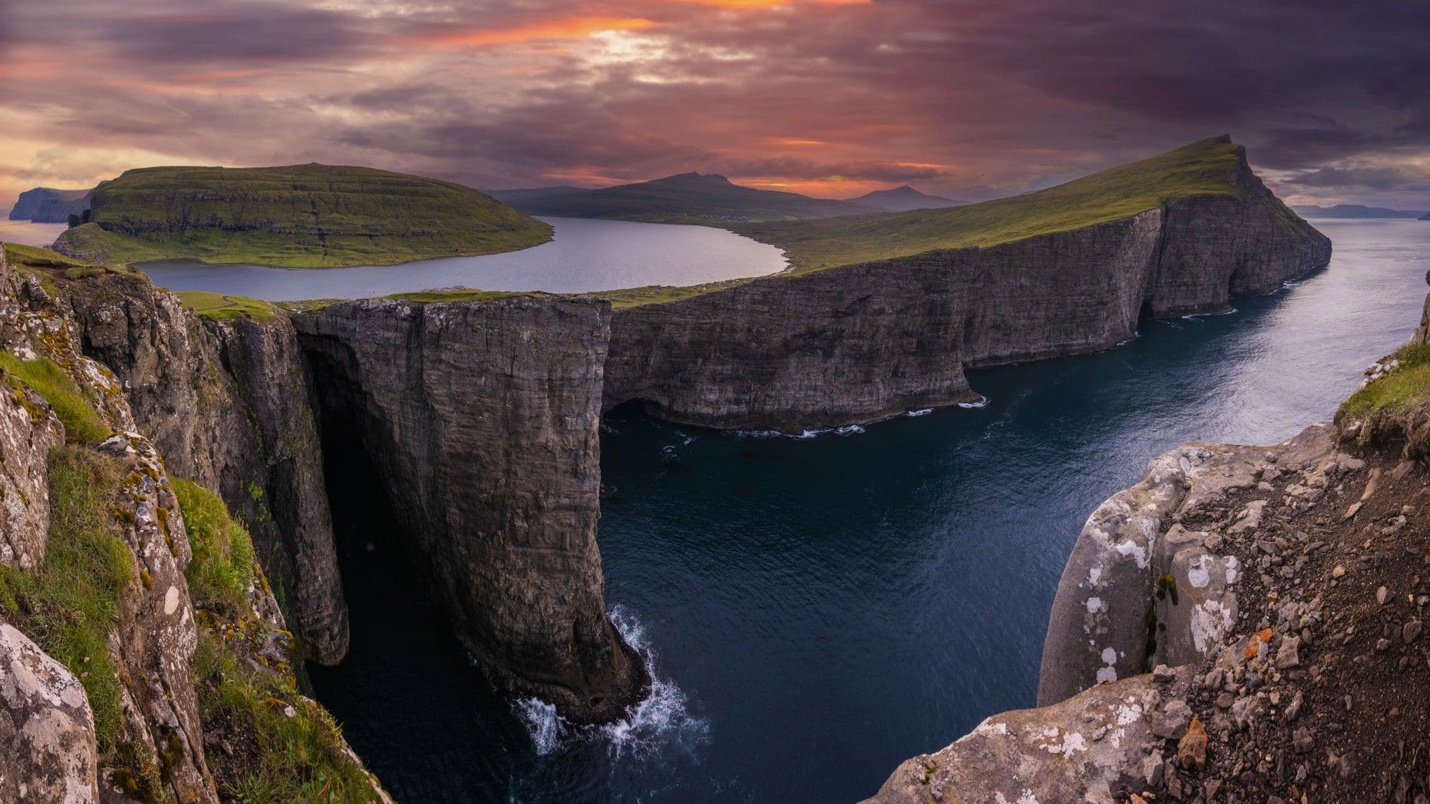
The striking visual phenomenon that has made Sørvágsvatn internationally famous is not the result of any supernatural occurrence or geological impossibility, but rather a sophisticated interplay between topography, perspective, and human visual perception. The lake is surrounded by towering cliffs that rise dramatically from the surrounding terrain, creating a unique geographical configuration that fundamentally alters how observers perceive the lake's elevation relative to sea level. When viewed from specific vantage points—particularly from certain angles that align the observer's line of sight with the surrounding cliff formations—the lake appears to be suspended impossibly high above the Atlantic Ocean's surface. This optical illusion is especially pronounced when viewing the area on either side of the lake's primary outlet, where the visual effect reaches its most dramatic and compelling manifestation.
Bøsdalafossur Waterfall: The Dramatic Outlet Creating Maximum Visual Impact
The most visually striking element of this optical illusion centers on Bøsdalafossur, a spectacular 100-feet-high (30 meters) waterfall that serves as the primary outlet for Sørvágsvatn's freshwater into the Atlantic Ocean. The name Bøsdalafossur translates to 'the waterfall at Bøsdal,' referencing the nearby settlement of Bøur and the geographical area known as Bøsdal. This dramatic waterfall, which plunges from the lake down the surrounding cliff face to the ocean far below, creates an extraordinary visual reference point that amplifies the optical illusion. The waterfall's existence and prominence serve as a natural focal point that, when photographed or viewed from the correct angle, makes the lake appear to hover impossibly above the water into which it flows. The sheer vertical drop of the waterfall—combined with the surrounding cliff formations and the observer's distance from these geographical features—creates a convergence of visual and spatial cues that fundamentally deceive the human eye and brain regarding the actual elevation and positioning of the lake relative to the ocean.
The Science Behind Visual Perception and Geographical Illusions
The phenomenon of Sørvágsvatn represents a compelling case study in how human visual perception can be systematically deceived by geographical features and spatial relationships. The human brain relies on a complex series of visual cues—including relative size, overlap, linear perspective, and atmospheric perspective—to judge distance and elevation in three-dimensional space. When these cues are disrupted or misaligned by unusual topographical configurations, the brain can arrive at conclusions about spatial relationships that contradict objective physical reality. In the case of Sørvágsvatn, the surrounding cliffs create a visual frame that suggests the lake occupies a higher elevation than it actually does, while the distant ocean provides a reference point that the brain interprets as being at a different elevation than it truly is relative to the lake itself. This misalignment of visual cues creates the compelling illusion that the lake floats above the sea, even though the lake actually drains into the ocean through the Bøsdalafossur waterfall at a lower elevation.
Tourism, Photography, and Global Recognition of the Faroe Islands' Natural Phenomena
The international attention garnered by Sørvágsvatn's optical illusion reflects a broader trend in contemporary tourism and digital media consumption. High-quality photography of the lake, particularly images captured from the optimal vantage point that emphasizes the floating illusion, has circulated extensively through social media platforms, travel blogs, and photography publications. This digital dissemination has transformed Sørvágsvatn from a locally known geographical feature into an internationally recognized natural wonder that attracts visitors specifically seeking to witness and photograph the optical illusion firsthand. The Faroe Islands, which have historically remained relatively isolated due to their remote North Atlantic location, have increasingly become a destination for adventure travelers, landscape photographers, and nature enthusiasts seeking dramatic and unusual geographical features. The global recognition of Sørvágsvatn has contributed to broader awareness of the Faroe Islands' exceptional natural environment, characterized by steep sea cliffs, powerful waterfalls, and dramatic volcanic landscapes that create some of Earth's most visually striking terrain.
Geographical Context: The Faroe Islands and Their Unique Landscape
Understanding Sørvágsvatn requires broader geographical context regarding the Faroe Islands themselves. The archipelago consists of 18 volcanic islands formed by intense geological activity millions of years ago, with the islands themselves representing the visible peaks of an extensive underwater mountain range. The Faroe Islands' landscape is characterized by extreme topographical variation, with sea cliffs reaching heights of up to 1,000 meters (3,281 feet) in some locations, making them among the highest sea cliffs in the world. The islands experience a subarctic oceanic climate, with frequent precipitation, strong winds, and dramatic weather patterns that have shaped the islands' distinctive appearance and challenging living conditions. Sørvágsvatn sits within this dramatic geological context, its freshwater composition contrasting sharply with the salt water of the surrounding Atlantic Ocean, while its position on the island of Vágar places it within one of the most scenically dramatic regions of the archipelago.
- Sørvágsvatn is a 1.3-square-mile (3.4 square kilometers) lake in the Faroe Islands that creates a compelling optical illusion when viewed from specific angles, appearing to float above the Atlantic Ocean
- The lake carries two names—Sørvágsvatn and Leitisvatn—reflecting competing historical claims from different Faroese communities, though locals commonly refer to it simply as Vatnið ('the lake')
- The optical illusion is created by surrounding cliff formations and the unique perspective provided by Bøsdalafossur, a 100-foot (30-meter) waterfall that serves as the lake's primary outlet
- The phenomenon demonstrates how human visual perception can be systematically deceived by topographical features and spatial relationships that misalign the brain's standard cues for judging distance and elevation
- Sørvágsvatn has become one of the most photographed natural features in the Faroe Islands, contributing to international tourism and broader recognition of the archipelago's exceptional geological and landscape features
Frequently Asked Questions About Sørvágsvatn and Optical Illusions in Geography
Frequently Asked Questions
- Is Sørvágsvatn actually floating above the ocean, or is it an optical illusion?
- Sørvágsvatn is entirely a visual illusion created by perspective and surrounding cliff formations. The lake is actually at a lower elevation than it appears from certain viewing angles, and it drains into the Atlantic Ocean through the Bøsdalafossur waterfall. The human brain misinterprets spatial cues provided by the surrounding topography, creating the compelling but false impression that the lake hovers above the sea.
- Why are there two different names for the lake?
- The lake is called Sørvágsvatn by western communities like Sørvágur, which was settled in the ninth century, and Leitisvatn by eastern communities like Miðvágur and Sandavágur. The naming dispute reflects competing historical settlement claims and regional identity. Most locals now simply call it Vatnið, meaning 'the lake,' to avoid the ongoing nomenclatural debate.
- What is Bøsdalafossur waterfall, and why is it important to the optical illusion?
- Bøsdalafossur is a 100-foot (30-meter) waterfall that serves as Sørvágsvatn's primary outlet to the Atlantic Ocean. The waterfall's dramatic vertical drop and surrounding cliff formations create visual reference points that, when viewed from specific angles, amplify the optical illusion and make the lake appear to float impossibly above the sea below.